|
|
 |
|
|
|
1901, July 7th; Tropical Storm "San Cirilo"
First storm to hit Puerto Rico in the 20th Century. The center of the storm moved over
the southwest tip of Puerto Rico in a northwesterly direction with estimated sustained winds of 70 mph in the early morning
of July 7th 1. The storm was mostly experienced in the southwest area of the island and produced rains
of 5 to 6 inches in 72 hours in Barranquitas, Caguas and Humacao. The wind report of San Juan was of 52 mph and a pressure
of 29.60 in/hg (1002 mb).
|
1901, September 11th-12th; Tropical Storm "San Vicente"
The center of this tropical storm moved over the north coast of Puerto Rico in a westerly direction
with estimated sustained winds of 60 mph during the night of September 11th and early morning of September 12th 1.
The wind report from San Juan was of 52 mph and a pressure of 29.89 (1012 mb). The storm affected all the crops in Puerto
Rico, specially the citrus.
|
1910, September 6th-7th; Hurricane "San Zacarias"
The eye of this hurricane passed around 20 miles south of the south coast of Puerto Rico in a westerly direction
with sustained winds estimated in 100 mph 1. Strong gusts were reported in the northeast side of the island
and in San Juan winds reached 72 mph with a pressure of 29.66 in/hg (1004 mb). The rest of the island apparently did not report
very much activity. The rare thing with this hurricane is that the worst conditions were experienced in the northeast side
of the island with the storm passing close to the south coast.
|
1915, August 11th; Hurricane "San Triburcio"
The storm passed around 100 miles south of Puerto Rico in a westerly direction with winds estimated in 100
mph near the center. Two people were drowned in the sea in Cabo Rojo, the storm caused mountainous seas in the south coast.
Also the agriculture was affected with crops damaged. The minimal pressure in San Juan was of 29.77 in/hg (1008 mb) and winds
of 62 mph. The strongest winds were experienced in the Central Mountain Range and the south.
|
1916, August 22nd; Hurricane "San Hipólito"
Estimated to be a small sized hurricane that crossed Puerto Rico from east to west. The storm's intensity
was estimated to be at 90 mph sustained at time of landfall and weakening as it crossed the island. San Juan reported winds
of 92 mph and a pressure of 29.82 in/hg (1010 mb). One death was attributed to the storm and the worst damage was reported
in the east and northern part of Puerto Rico, specially Santurce. The monetary damage is estimated at $1,000,000 dollars.
|
1921, September 9th-10th; Hurricane "San Pedro"
This hurricane passed well south of Puerto Rico in a west-northwesterly direction as a category one storm, then it moved
in a northerly direction over eastern Hispaniola re-curving into the open Atlantic passing close to Bermuda. Cabo Rojo, PR
had winds of 60 mph and a pressure of 29.68 in/hg (1005 mb) and Ponce reported a pressure of 29.70 in/hg (1006 mb). The winds
measured in San Juan were of 44 mph with a pressure of 29.82 in/hg (1010 mb). The main effect of the storm was heavy surf
in the south coast and damage was minimal, one death was reported.
|
1926, July 23rd-24th; Hurricane "San Liborio"
The storm entered the Caribbean Sea by Martinique and strengthening as
it moved in a general west-northwest heading until making landfall in the southwest of Puerto Rico with estimated sustained
winds of 80 mph the night of July 23rd. The winds in San Juan were measured of 66 mph and a pressure of 29.62 in/hg (1003
mb). The hurricane killed 25 people and damage estimates are of $5,000,000 dollars. Many houses were destroyed around the
island.
|
1928, September 13th; Hurricane "San Felipe II"
This is considered one of the most intense hurricanes in the history of the Antilles and the strongest in
Puerto Rico's history. This infamous hurricane developed in the area of the Cape Verde Islands reported in September 6th.
Moving generally in a westerly direction for the next few days, the storm strengthened into hurricane intensity and further
increasing its force passed over the island of Guadeloupe the afternoon of September 12th with sustained winds estimated to
be near 125 mph (110 kts) and a reported pressure in the island of 940 millibars. As the storm entered the Caribbean Sea it
continued to strengthen becoming a category 5 intensity (Saffir-Simpson Scale) hurricane.
"San Felipe" made landfall in Southeast Puerto Rico in the vicinity of Guayama-Arroyo at around 2 PM AST
September 13th with officially estimated sustained winds of 160 mph and a measured pressure in Arroyo of 27.50 in/hg or 931
millibars (It is not known if this pressure was actually measured in the eye). For the next eight to ten hours the eye of
the hurricane crossed Puerto Rico from southeast to northwest without losing much strength, still with category 5 intensity
when it left the northwest side of the island in the vicinity of Aguadilla at around 10-11 PM AST September 13th. The wind
report from San Juan was of sustained 160 mph at around 1 PM AST before the instrument was destroyed by the winds. Stronger
winds were probably felt after the instrument was destroyed, this are the highest sustained winds ever reported in Puerto
Rico. As the official intensity estimates are of 160 mph (140 kts) when the storm hit Puerto Rico, there are estimates of
sustained winds in the area of 180-200 mph were the strongest part of the eyewall passed over, which was the southeast coast
of the island. Damage surveys in the aftermath of the storm reveal that there was catastrophic destruction all around Puerto
Rico, but that the towns which were directly in the path of the eye and strongest part of the eyewall were literary "blown"
out of the map. This was the case in places like Guayama, Arroyo all the way north to Naguabo and westward. The storm was
also very big as estimates are of hurricane conditions in Guayama during 18 hours ( 4 am-10 pm September 13th) and San Juan
during 12 hours ( 4 am-4 pm September 13th). Rain reports were of 29.60 inches of rain in 48 hours.
After blasting Puerto Rico the hurricane continued in a west-northwesterly direction over the Bahamas Islands
as a category 4 storm finally making landfall in the vicinity of West Palm Beach, Florida in the night of September 17th with
estimated sustained winds of 150 mph (130 kts) and a measured pressure of 929 millibars. The storm made catastrophic damage
in Florida also causing a storm surge in Lake Okeechobee showing the massive size and power of the storm, at least 1,800 deaths
were caused by the storm in that state. The storm moved further inland into Florida and the eastern side of the United States
while finally dissipating near the Great Lakes area in September 20th.
As mentioned above, Puerto Rico was devastated by the storm and the towns were the eye passed directly over
were the worst affected with many places becoming unrecognizable after the event. At least 312 deaths were related to the
hurricane. Damage estimates are of $50,000,000 dollars (Which for that time is a very high amount). A total of 24,728 houses
were completely destroyed and 192,444 were severely affected. Almost no building in Puerto Rico survived the hurricane
without any damage 2. Many sugar cane factories which were new at that time and were valued at millions of dollars were
reduced to debris by the hurricane. The coffee crops were all lost and coffee was imported to Puerto Rico from 1929 to 1934
to satisfy local demand 3. The economy of Puerto Rico which was struggling before the hurricane was further affected by it
and it took more than a decade to recuperate entirely from the effects of this infamous storm which to the date, is the strongest
hurricane to hit Puerto Rico in it's history.
|
1931, September 10th-11th; Hurricane "San Nicolás"
Category 1 hurricane that crossed the north coast of Puerto Rico from east to west with estimated sustained winds of 90
mph. The storm made landfall in Fajardo at 8 PM leaving the island by Aguadilla at 2 AM. The hurricane continued in a westward
track across the south of Hispaniola and into Yucatan and Mainland Mexico. The winds in San Juan reached 90 mph from the northwest
and a pressure of 29.17 in/hg (987.8 millibars) at 10 PM AST. The hurricane lasted around 2 hours in San Juan. Two people
died in the storm and the worst damage was to agriculture, estimates are of $200,000 dollars.
|
1932, September 26th-27th; Hurricane "San Ciprián"
Only four years after hurricane "San Felipe" yet another major storm hits Puerto Rico. "San
Ciprián" developed east of the Northern Leeward Islands and strengthened fast becoming a hurricane and crossing St. Marteen,
Anguilla and the Virgin Islands as a category 3 hurricane the day of September 26th. The eye of the hurricane made landfall
in Eastern Puerto Rico around 10 PM AST September 26th and crossing the island during the next 7 hours until exiting Puerto
Rico near Mayaguez at 5 AM AST September 27th. Winds at time of landfall in Puerto Rico are estimated to be of sustained 120
mph or category 3 intensity. There is a pressure report from two ships in Ensenada Honda, Ceiba (landfall point of the hurricane)
which measured 27.70 in/hg (938 millibars) and 28.00 in/hg (948 millibars). These pressure reports support at least a category
3 intensity hurricane at landfall in Puerto Rico. In San Juan the anemometer broke when the winds reached 66 mph, and they
reported a pressure of 980 millibars when the eye of the hurricane passed to their south at around 1 AM AST September 27th.
After affecting Puerto Rico, the hurricane continued in a westward motion across the south coast of Hispaniola and weakening
to tropical storm status finally dissipating over Mexico in October 3rd.
Damage in Puerto Rico was extensive all across the island and 225 people died as
a result of the storm, damage estimates are of $30,000,000 dollars. Many of the deaths were caused by the collapse of buildings
or flying debris. A total of 25,000 people lost their homes and 46 municipalities were severely damaged. In the agriculture,
the citruses were the worst damaged because they were in the worst affected area. In Arecibo a total of 24 people died when
they took shelter in a building that collapsed during the hurricane. Puerto Rico was still recuperating from "San Felipe"
and this storm brought more misery and desolation to the island.
|
1943, October 14th; Hurricane "San Calixto"
This hurricane passed far south of Puerto Rico in a westerly direction, then suddenly the storm turned in
a northward direction passing 70 miles west of Puerto Rico and near Punta Cana, Dominican Republic as a category 1 hurricane
(90 mph). The storm ended in Nova Scotia. Winds of 60 mph were reported in the west of Puerto Rico, this caused damage to
houses from Cabo Rojo to Aguadilla. Rains of 12 to 18 inches caused flooding in the rest of the island. No deaths were reported,
for first time the Reconnaissance Aircrafts to study the cyclone.
|
1949, September 21st; Hurricane "San Mateo"
Short-lived hurricane that passed some 40-60 nm south of Puerto Rico with winds estimated of 80 mph near the
center. In Saint Croix the damage was strong but the effects in Puerto Rico were relatively minor, mainly in the south and
southwest side. In Ramey AFB, Aguadilla winds of 64 mph were measured and in San Juan the winds reached 38 mph. Almost all
of the rivers flooded.
|
1956, August 12th, Hurricane Betsy (Santa Clara)
Hurricane Betsy developed from a tropical wave in August 9th east of the Lesser Antilles. The storm rapidly
strengthened reaching hurricane status reaching an estimated peak of intensity of sustained 120mph (105 kts) winds and weakening
before passing over the island of Dominica and very near the southwest of Guadeloupe in the afternoon of August 11th. At this
time the storm was estimated to have winds of 90 to 110 mph. The hurricane continued moving straight to Puerto Rico making
landfall in the southeast of the island by the town of Patillas at 8 AM AST August 12th. The intensity of the hurricane at
this time was estimated to be at 90 mph and the storm was moving at a fast forward speed of 21 mph with an eye of 14 nm in
diameter. In only 3 hours the eye of the hurricane crossed Puerto Rico leaving the island by Arecibo (north coast) at 11 AM
AST August 12th. San Juan reported winds of 92 mph, a pressure of 29.56 in/hg (1001 mb) and rain totals of 3.19 inches. Ramey
AFB in Aguadilla reported sustained winds of 85 mph with a gust of 115 mph. The highest rainfall report was in Rio Grande
with 8.70 inches. After passing over Puerto Rico, Betsy continued in a northwest track strengthening back to category 2 intensity
and re-curving northeastward into the open waters of the Atlantic losing its tropical characteristics as it moved into cooler
waters by the 20th of August.
Damage made by "Santa Clara" in Puerto Rico was bad in the southeast, central and northern areas of the island,
the hurricane did not impact very much the southwest side. A total of 16 peopled died in the storm and 15,000 houses were
destroyed. Damage estimates are of $40,000,000 dollars. This is the first hurricane that was tracked in radar as it crossed
Puerto Rico.
|
1960, September 5th-6th; Hurricane Donna (San Lorenzo)
Hurricane Donna is one of the infamous Atlantic hurricanes due to the path of destruction the
storm left from the Caribbean trough the Bahamas, Florida and the Eastern Seaboard of the United States. In Puerto Rico the
effects of Donna were associated with deadly flashfloods which killed over 100 people when the storm passed 70 nm northeast
of the island. Donna originated from a tropical wave which became a tropical depression south of the Cape Verde Islands on
August 29th. Moving in a classic Cape Verde track the depression became a tropical storm in August 30th as it was approaching
the Lesser Antilles. Tropical storm Donna became a hurricane in September 1st and still intensifying until reaching its peak
of intensity of 160mph (140 kts) sustained winds when the storm was about 100 nm east-northeast of Guadeloupe in August 4th.
Hurricane Donna weakened somewhat before passing very close to Antigua and near of over Barbuda, St. Marteen and Anguilla,
by this time the hurricane was estimated to have winds of 150 mph when it hit Antigua and Barbuda weakening steadily to 130-135
mph when it passed the St. Marteen area. Donna continued in a west-northwest track passing close to the north of the Virgin
Islands, 36 nm north of St. Thomas and 70 nm northeast of Fajardo, Puerto Rico the afternoon of September 5th with winds estimated
to be at 125-130 mph near the center. The hurricane then moved in a more westward track across the Bahamas blasting the island
as a category 4 storm estimated to have winds of 150 mph at that time. After that, the hurricane made landfall in the Middle
Florida Keys in the early morning hours of September 10th with winds of 140 mph and a pressure of 932 millibars. Then the
huricane started to recurve over the state making a second landfall near Napes, Florida still as a category 4 intensity hurricane
emerging near the city of Daytona as a borderline category 3-4 hurricane and making two more landfalls in the North Carolina
Outer Banks and Long Island, New York as a category 2 hurricane, after that the hurricane lost its tropical characteristics
dissipating over Eastern Canada in September 14th.
Damage in Puerto Rico was mainly due to rain, not much wind was experienced in the island. Rainfall
amounts were tremendous with estimates of 15 to 20 inches of rain in a 6 to 10 hour period, which can be a record for Puerto
Rico. These excessive rainfall amounts caused all rivers to flood over their banks killing 107 people by drowning. The worst
floods occurred in the eastern half of the island with much of the deaths registered in the city of Humacao were the river
claimed most of the lives. The Red Cross reported 137 people death or missing, 519 destroyed houses and 3,762 houses affected.
Many people did not took precautions even with the warnings issued resulting in the tragedy in Humacao were people did not
abandoned their houses and when the river came and swept away their houses, with them inside. As well as in Puerto Rico, the
Leeward Islands, Bahamas and United States suffered heavy damage by this powerful hurricane. In Florida the Keys were blasted
by the full force of the winds and storm surge of the hurricane with many islands under the water during the height of the
storm. The damage path continued all across the Florida Peninsula and the Eastern Seaboard all the way up to New York City
and Boston.
|
|
1961, October 2nd-3rd; Tropical Storm Frances
Tropical storm Frances developed just east of the Lesser Antilles in September 30th passing
just southwest of Puerto Rico in the night of October 2nd and morning of October 3rd. Heavy rains were reported in the southwest
of the island and winds of 35 mph reported. The storm was estimated to have winds of 60 mph at closest
point of approach. Frances the strengthened to hurricane intensity re-curving into the Atlantic and dissipating in October
10th. No deaths associated to the storm in Puerto Rico.
|
|
1963, September 26th; Hurricane Edith
This hurricane formed just east of the Lesser Antilles on September 23rd and intensifying until passing Near
St. Lucia as a category 2 intensity hurricane. After weakening the hurricane passed around 20 miles southwest of Puerto Rico
with winds of 75 mph night of September 26th. Edith then hit the Dominican Republic and dissipated over the Bahamas in September
29th. The hurricane caused some damage to bridges and crops in the south of Puerto Rico.
|
|
1964, August 23rd; Hurricane Cleo
Hurricane Cleo formed east of the Lesser Antilles moving in a westward track in August 20th. During the next
few days the storm strengthened until reaching hurricane intensity and blasting Guadeloupe with winds of 130-135 mph sustained
on August 22nd. After that, Cleo continued in a westward track passing 100 nm south of Puerto Rico with winds of 155 mph causing
minor damage and with winds of 52 mph reported in Punta Tuna, Maunabo. The hurricane passed just south of Barahona, Dominican
Republic and over southwestern Haiti as a category 4 hurricane, weakening and crossing Eastern Cuba the eye of Cleo moved
over South Florida as a rapidly strengthening category 2 hurricane with winds of 105 mph and a pressure of 968 millibars.
The Cleo re-curved inland over the North Carolina area and moved out into the ocean were it regained hurricane intensity finally
dissipating east of Nova Scotia on September 5th.
|
|
1966, August 26th; Hurricane Faith
Hurricane Faith developed east of the Lesser Antilles in August 21st and moving in a general
westward direction and intensifying until becoming a hurricane. Faith passed around 90 nm north of San Juan moving west-northwest
with winds of 85 mph near the center. Wind reports in San Juan were of 45 mph and minimal damage. The hurricane caused high
seas in the north coast. After that, the hurricane re-curved after reaching the peak intensity of 125mph.
|
|
1966, September 28th; Hurricane Inez
Inez was a powerful hurricane that passed around 70 nm south of Puerto Rico in September 28th. The winds
at that time were estimated to be of 150 mph sustained near the center. Inez developed east of the Antilles in September 21st
and moved towards the islands until reaching Guadeloupe in September 27th, the storm was estimated to have winds of 125 mph
when it hit the island. Inez continued to strengthen as it moved south of Puerto Rico and over Southern Hispaniola, then having
a very erratic track over Cuba, South Florida, Yucatan and finally Mainland Mexico in October 11th. A reconnaissance aircraft
measured a wind of 197 mph at 4,000 feet when the storm was south of Puerto Rico. At that time it was the record of speed
for cyclones in the area. In Puerto Rico the highest winds were of 52 mph in Tallaboa, Peñuelas and in Mona Island the winds
were estimated in the 70-80 mph range. Damage was minimal in Puerto Rico.
|
|
1967, September 9th, Hurricane Beulah
Powerful category 4 hurricane that passed some 40 miles to the southwest of Puerto Rico with
winds estimated of 145 mph near the center. Beulah formed east of the Antilles in September 5th and moved over the St. Lucia
area as a tropical storm, then the storm rapidly strengthened to hurricane intensity and reaching major hurricane status south
of Puerto Rico. The hurricane made a sharp turn to the left passing just south of Hispaniola and weakening
fast, then the hurricane hit Yucatan as a category 2 storm and making a final landfall in the Brownsville, Texas area as a
category 3 intensity hurricane, finally dissipating inland in September 22nd. Damage in Puerto Rico was in the south coast,
to beach houses, boats and roads.
|
|
1975, September 15th-16th; Tropical Storm Eloise
Eloise passed 30 to 40 nm north of Puerto Rico as a tropical storm moving in a westward direction.
Eloise became a tropical depression in September 13th and maintaining that strength as it moved over the extreme Northern
Leeward Islands. When it passed north of Puerto Rico the system reached tropical storm status and it was estimated to have
winds of 50 mph as it moved north of the island. Then the storm briefly reached hurricane intensity making landfall in the
Puerto Plata, Dominican Republic area in September 17th with winds estimated to be at 75 mph. Eloise ended making landfall
in the Florida Panhandle in September 23rd with winds of 125 mph (110kts) and a pressure of 955 millibars. This resulted in
very extensive wind and storm surge damage in the area and also an outbreak of tornadoes associated with the storm. In Puerto
Rico the damage was caused by very heavy rainfall and extensive flooding around the island. The southwest side was the worst
affected and 44 people died by drowning. Rainfall data indicate that the record of 23 inches of rain in 24 hours by hurricane
"San Ciriaco" in 1899 may have been exceeded but the information cannot be confirmed.
|
|
1979, July 17th-18th; Tropical Storm Claudette
Claudette was a weak tropical storm that passed over the north coast of Puerto Rico in a westward direction.
Apparently the storm weakened to tropical depression strength just before landfall. Claudette never got very much strength
and ended making landfall near Corpus Christy, Texas in July 24th. The winds were estimated to be around 50 mph, apparently
the storm brought a lot of rain to the area because damage estimates are of $609 million dollars. Damage in Puerto Rico was
minimal.
|
|
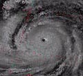
1979, August 30th; Hurricane David
Hurricane David originated from a tropical wave that emerged from the west coast of Africa becoming
a tropical depression in August 25th east of the Windward Islands. Moving in a westward direction the system continued to
organize and became a tropical storm and later a hurricane as it was getting closer to the islands. David became a powerful
category 4 hurricane as it blasted through the islands of Martinique and Dominica with sustained winds of 145 mph and a pressure
of 933 millibars the afternoon of August 29th. This resulted in massive destruction in those islands. David continued moving
west-northwestward passing around 70 nm southwest of Puerto Rico with an amazing intensity of 175 mph sustained winds and
a pressure of 924 millibars. David weakened slightly and re-strengthened just prior to landfall near Santo Domingo, Dominican
Republic with estimated sustained winds of 175 mph and a pressure of 926 millibars in the afternoon of August 31st. David
is one of the worst hurricanes in the Dominican Republic's history, damage was catastrophic and more than 1,200 people died
and many others were left homeless and in the misery. The high mountains of Hispaniola almost killed David from a powerful
category 5 hurricane to a tropical storm when it left the island by the coast of Haiti, and skimming Cuba. David passed just
east of Miami in a northward direction as a category 1 hurricane and strengthened to 100 mph moving along the coast from West
Palm Beach all the way to the Georgia-South Carolina border as a category 1 hurricane. David ended losing its tropical characteristics
in September 8th.
David is one of the worst hurricanes to hit the Caribbean in the 20th Century. When the hurricane
passed south of Puerto Rico, hurricane conditions were experienced in the southeast, south and southwest areas of the island
with estimated sustained winds of 75-85 mph. The rest of the island experienced tropical storm winds gusting to hurricane
force at times. The seas became extremely violent in the south coast of the island and flooding was severe all across the
island, specially in the north coast. A total of 7 people died during the storm. David was followed by tropical storm Frederick
5 days later.
|
|
1979, September 4th; Tropical Storm Frederick
Only 5 days after David, tropical storm Frederick passed directly over Puerto Rico. Frederick
developed east of the Antilles on August 29th following the track of David. Becoming a hurricane east of the Leeward Islands,
Frederick found some strong upper-level wind shear due to the outflow of hurricane David. The weak storm crossed Puerto Rico
from east to west with winds of 50 mph and a pressure of 1004 millibars.
After passing over Puerto Rico, Frederick affected the Dominican Republic, Haiti, Cuba and entering
the Gulf of Mexico were it became a powerful category 4 hurricane. Frederick ended making landfall in the Mississippi-Alabama
coasts with sustained winds of 135 mph and a pressure of 946 millibars in the night of September 13th. Damage to the area
was very heavy and estimates are of $3.5 billion dollars in damage, one of the most expensive hurricanes of all times in the
United States. In Puerto Rico the damage was caused by flooding and damage estimates cannot be separated between David and
Frederick, and are a total of $125 million dollars.
|
1. Data taken from the "Atlantic Hurricane Re-Analysis Project" by Dr. Chris Landsea, Bob Hart
& Andy Solow.
2. "El Nuevo Día" article "La marejada ciclónica de San Ciriaco" of June 22nd, 1997 by Angel L. Rosado Bauza
"Historic Cyclonic Puerto Rican Society".
3. Much of the information of damage and some pressure reports found from the book "Historia de los huracanes
en Puerto Rico" or "History of Hurricanes in Puerto Rico" by Edwin Miner Solá (1995).
4. National Hurricane Center (NHC) tracking maps used.
| Hurricane David approaching the Dominican Republic |
|
|
| August 31st 1979 |
| Hurricane David near time of landfall |
|
|
| August 31st 1979 |
|
|
|
|
|
|
|
|