Hurricane Hugo developed from a tropical
wave in the area south of the Cape Verde island in September 10th 1989 when it became a tropical depression were it continued
to intensify to tropical storm intensity in September 11th. The storm was steadily moving in a general westward track and
it became a hurricane in September 13th when it was still east of the Lesser Antilles, the storm continued the intensification
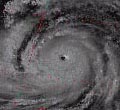
process towards its peak of intensity of max. sustained winds of up to 160mph (140kts) and a minimal pressure of 918mb measured
by the Hurricane Hunters in the afternoon of September 15th 1989. In that mission the airplane was almost lost due to extremely
severe turbulence in the eyewall of the deepening storm but thankfully the airplane was able to do an emergency landing in
Barbados. Favorable upper-level conditions and a strong ridge to the north of the tropical cyclone made Hugo become such a
formidable storm and took it westward across the Atlantic Ocean towards the Lesser Antilles. After Hugo peaked out with the
category 5 intensity the storm leveled off to category 4 intensity all the way across the Lesser Antilles were it made landfall
in Guadaleoupe with max. sustained winds of 140mph (120kts) causing severe damage to the island. Then the storm continued
moving westward (W) over the island of Monserrat and then turning WNW in September 17th towards the US Virgin Islands and
Puerto Rico.
Hugo's intensity was fluctuating
at times but the storm was pretty much in the same category 4 intensity until it made landfall in St. Croix, USVI in the early
morning hours of September 18th with max. sustained winds of 140mph (120kts) and a minimal pressure of 934mb. Damage in St.
Croix was very severe were almost every structure was either damaged or destroyed in the island. Then the storm continued
moving in a general WNW to NW track towards the island of Vieques, Puerto Rico were it made landfall at 7am September 18th
when the storm was estimated to be down to a borderline category 3-4 hurricane with winds of up to 130mph (110kts) and a pressure
of 945mb. One hour later the storm made landfall in eastern Puerto Rico in the area of Fajardo and Ceiba leaving the island
by the area of Luquillo and Rio Grande about two hours after landfall. The storm was also estimated to have winds of 130mph
gusting to 160mph and the pressure measured in Roosevelt Roads in Ceiba was 946.1mb. The eye also passed very near or over
Culebra, Puerto Rico and then the storm continued moving northwest passing 20 miles north of San Juan while weakening due
to southwest shear and interaction with land. It may be noted that based on the amount of damage and the very near category
4 intensity of Hugo at landfall in Puerto Rico that the damage was very severe in the eastern side specially in the areas
were the eyewall was experienced were the damage estimates are of sustained category 4 conditions in St. Croix, Vieques, Culebra
and extreme Eastern Puerto Rico.
The storm then continued moving and weakening
heading northwest then intensifying back to category 4 intensity when it made landfall near Charleston, SC in the early morning
hours of September 21st 1989 as a 140mph (120kts) hurricane with a pressure of 933mb becoming the costliest storm in the US
history with 7 billion dollars in damage being supperated by Andrew in 1992.
Wind-Pressure Reports in Puerto Rico and
USVI:
The highest sustained wind speed measured
in the area was in Roosevelt Roads with 105mph (90kts) sustained gusting to 120mph (105kts) and a minimal pressure measured
of 946.1 millibars. It has to be noted that those peak winds were measured from the West and there is El Yunque mountain of
over 3000ft high which might have blocked stronger winds. Culebra island in a more exposed area and in the northeast eyewall
of the storm had an unnoficial wind speed report of a gust to 170mph (148kts) before the instrument was lost, this was in
the harbour. San Juan reported sustained winds of 77mph (67kts) with a gust to 92mph (80kts) also with unofficial reports
of 110mph (95kts) gusts in other parts of the San Juan Metro Area. The highest rainfall amount measured in Puerto Rico was
of 9.20 inches in my hometown of Gurabo in Central Eastern Puerto Rico, but it also has to be mentioned that in such intense
winds in the eyewall in the storm would be hard to measure rainfall due to horizontal rain so higher rainfall amounts may
have been possible in the area were the eyewall passed over.
Damage in Puerto Rico and USVI:
Damage in the USVI was extensive with
extremely severe destruction in St. Croix were almost every structure was either damaged or destroyed.
In Puerto Rico the damage was extensive
in the east half of the island and it was specially severe in the eastern and northeastern areas of the island from Humacao
northward to Rio Grande with 115 to 140mph sustained winds estimated based on damage, Roosevelt Roads Naval Station was very
hard hit along with the mentioned area. Damage in the rest of the areas including San Juan was also extensive but at a lesser
amount and the west and south sides of the island were left either with minimal or no damage. Vieques and Culebra also had
the same damage situation than St. Croix and the Eastern part of Puerto Rico with around 80% of the houses either damaged
or destroyed in both islands, specially in Culebra.