|
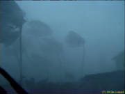
| Eyewall of Georges blasting in Luquillo, PR |
|
| Photo by Jim Leonard |
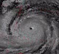
Hurricane Georges was the worst hurricane to hit Puerto
Rico since hurricane "San Ciprian" in 1932. It was a category 3 intensity hurricane that crossed the entire island from east
to west leaving destruction and damage all across.
Georges developed from a strong tropical wave that emerged
from the west coast of Africa in the vicinity of the well known Cape Verde Islands which in September are a very common place
for the development of strong tropical cyclones. A tropical depression was born in the morning of September 15th and 24 hours
later it became tropical storm Georges, moving west in the far eastern Atlantic posing no inmediate threat to any land areas.
The day later Georges steadily intensified becoming a hurricane. By September 19th Georges started a rapid-deepening process
which led the storm to reach its peak of intensity in the morning of September 20th with max. sustained winds of 155mph/135kts
and a minimun barometric pressure of 937mb, that happened when the storm was less than 300nm east of the Northern Leeward
Islands. After this point the storm started a marked weakening trend with the pressure rising 26mb in less than 12 hours and
the eye becoming less distinct. This weakening could be related to northerly upper-level wind shear that disrupted the structure
of the hurricane due to an upper-level anticyclone located over the eastern Caribbean.
Then early in the morning of September 21st Georges
made landfall in Antigua with top sustained winds of 115mph/100kts passing hours later over St. Kitts and Nevis still with
the same intensity. With the intensity decreasing to 110mph/95kts shortly after passing St. Kitts and Nevis, Georges found
better upper-level conditions with the shear diminishing and the outflow improving as the storm was approaching Puerto Rico.
Later in that morning the eye of the hurricane moved over St. Croix, USVI and approaching Vieques, Puerto Rico. Satellite
and radar images from Puerto Rico showed Georges becoming better organized as it was getting closer to Vieques. Georges passed
over Vieques in the mid afternoon and around 6pm the eye of the hurricane made landfall in Eastern Puerto Rico with max. sustained
winds of 115mph/100kts and a pressure of 967mb as the storm was intensifying and was back to category 3 intensity. This increase
in the winds was based on 110mph/96kts sustained winds measrured in Fajardo, Puerto Rico when the eyewall of the storm came
ashore, this report was the reason for increasing Georges back to category 3 intensity at landfall in Puerto Rico. In adition
to that, the WSR-88D Doppler Radar in San Juan estimated sustained winds of 115mph/100kts when Georges was over Puerto Rico.
Georges continued in a west/west-northwest direction over Eastern Puerto Rico with a very impressive eastern eyewall showed
in the San Juan Radar. Georges passed 20nm south of San Juan at around 8pm, right over my hometown of Gurabo where the calm
was experienced for more than 30 minutes followed by very turbulent and strong winds from the south asociated with the very
strong eastern eyewall of the hurricane which lasted for several hours in my place. San Juan Intl. Airport (SJU) measured
sustained winds of 79mph/69kts with a gust of 93mph/81kts at around 7:20pm of September 21st. The main reason for measuring
lower winds in San Juas was the blockage of the Mountain Range south of the city, while cities like Caguas in Central Eastern,
Puerto Rico where much affected by the strong winds also by the "Fujiwara Effect" of acceleration between mountains and valleys.
The eye of the storm then continued moving now west over Central Puerto Rico and the land interaction for many hours caused
the storm to weaken back to category 2 intensity with 110mph/95kts sustained winds as it was crossing the western part of
the island. The eye of hurricane Georges left Western Puerto Rico at around 1am September 22nd still as a strong category
2 intensity hurricane 7 hours after landfall.
Georges continued over the Mona Passage passing over
Mona and making landfall in Eastern Dominican Republic with sustained winds of 120mph/105kts and a pressure of 962mb later
in the morning of September 22nd. The storm started to move in a more west-northwest direction over Dominican Republic passing
just north of Santo Domingo and into the high mountains of Central Hispaniola. The storm lasted 21 hours over land weakening
to 75mph/65kts in the morning of September 23rd making landfall later that day with the same intensity over Eastern Cuba.
Still with a very impressive upper-level outflow, the storm left the north coast of Cuba by late afternoon September 24th
and moving in a more northwesterly direction. Georges made landfall in Key West, Florida in the morning of September 25th
with sustained winds of 105mph/90kts and a pressure of 981mb and then continued to move over the Gulf of Mexico intensifying
further to 110mph/95kts and making its final landfall near Biloxi, Mississippi on the morning of September 28th with max.
sustained winds of 105mph/90kts and a pressure of 964mb. Georges moved inland and became quasi-stationary being downgraded
to tropical storm and dissipating early in the morning of October 1st.
Path of Destruction:
Georges was the second most destructive hurricane of
the 1998 hurricane season after hurricane Mitch. A total of 602 deaths are directly assosiated to the path of the hurricane,
this happened mainly in the Dominican Republic and Haiti due to the very heavy rains which caused a lot of flooding and mud
slides as the storm came through Hispaniola.
In terms of damage, hurricane Georges left a path of
destruction from the Leeward Islands to the USVI, Puerto Rico, Dominican Republic and Haiti, Cuba, the Florida Keys and the
states of Mississippi, Louisiana, Alabama and the florida Panhandle. In the United States the damages estimates are of nearly
$6 billion dollars.
Puerto Rico was hard hit by Georges with up to 72,605
houses affected by the storm of which 28,005 houses were completely destroyed. More than 26,000 people took shelter during
the storm and a very high number was still in shelters during the aftermath of the hurricane. A 95% of the banana crop was
destroyed and 75% of the coffee crop was lost. The entire electric system of the island was shut down by the hurricane and
nearly the entire island was also without water. So far only 30,000 customers lost telephone service manily due to the new
fiber optic lines installed all around the island. The road infrastructure was very affected mainly by flooding and muslides.
The total damage estimates for Puerto Rico are of $1,907,026,374.
Wind reports from official sites in Puerto Rico :
|
|
|
Max. Sustained Wind (mph) / Direction
|
|
|
|
September 21st 7:02 PM AST & 6:49 PM AST
|
|
|
|
Carolina, Luis Muñoz Marín Intl. Airport (TJSJ)
|
September 21st, 7:24 PM AST & 7:18 PM AST
|
79 / Northeast
|
93 / Northeast
|
Wind reports from unofficial sites in Puerto Rico:
|
|
|
Max. Sustained Wind (mph) / Direction
|
Max. Wind Gust (mph) / Direction
|
|
|
September 21st - 7:40 PM AST
|
|
|
|
|
September 21st - 5:15 PM AST & 5:30 PM AST
|
|
|
|
|
September 22nd - 2:10 AM AST
|
|
|
|
|
September 22nd - 12:45 AM AST
|
|
|
|
|
September 21st - 10:44 PM AST
|
|
|
|
Naranjito
|
September 21st - 8:40 PM AST
|
|
125
|
1 Not known if actual measurement or estimate.
2 Highest known sustained wind reported in Puerto Rico.
3 Highest reported gust in Puerto Rico.
4 GMT + 0400 hours.
Lowest Pressure Reports from Puerto Rico
|
|
|
|
|
|
September 21st - 4:20 PM AST
|
|
|
|
September 21st - 5:45 PM AST
|
|
|
|
|
|
|
|
|
|
|
|
September 21st - 7:11 PM AST
|
|
1 Lowest pressure reported in Puerto Rico.
Highest Rainfall Amounts (inches) in Puerto Rico
|
|
|
|
|
Lago El Guineo Damsite (Villalba)
|
|
|
|
Rio Saliente at Coabey (Jayuya)
|
|
|
|
|
|
|
|
|
Quebrada Salvatierra (San Lorenzo)
|
|
|
|
Rio Grande de Arecibo (Utuado)
|
|
|
|
|
|
|
|
|
Rio Espiritu Santo (Rio Grande)
|
|
|
|
It has to be noted that tornadic activity asociated with the path
of the hurricane was reported in Puerto Rico with 3 tornadoes officially detected by the San Juan Doppler Radar located in
Cayey.
Most of the information was recopilated from sources like the National
Hurricane Center (NHC) in Miami and the San Juan National Weather Service (NWS).
|